Data repository for the human footprint in Mexico
How to cite this data page: Gonzalez-Abraham C, Ezcurra E, Garcillán PP (2015) Human Footprint in Mexico database. Ezcurra Lab, UCR. Dataset. http://dx.doi.org/10.13022/M3RG69
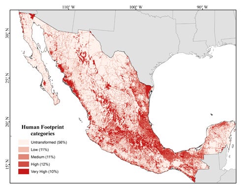
General description: This page contains two original maps developed by the authors: (a) the human footprint in Mexico (HF) and (b) the mean human footprint for whole Mexican ecoregions. We are also sharing most of the base layers used to calculate the HF index. All database file layers are in ESRI shapefile format. The base layers (base maps) used to generate the human footprint index for all Mexico are publicly available with the exception of the map of highways and roads, the links for which are given below.
Published together with the paper: González-Abraham C., E. Ezcurra, P.P. Garcillán, A. Ortega-Rubio, M. Kolb, and J.E. Bezaury-Creel. 2015. The Human Footprint in Mexico: Physical Geography and Historical Legacies. PLoS ONE 10(3): e0121203. doi:10.1371/journal.pone.0121203
Human footprint map (to download a high resolution copy click on the map)
1. General geographic coordinate reference and projection system
Geographic coordinate reference: GCS_North_American_1983
Projection: NAD_1983_Albers
Coordinate reference details
Projected coordinate system
X origin: -16688100
Y origin: -9068200
XY scale: 269868926.20313245
Z origin: -100000
Z scale: 10000
M origin: -100000
M scale: 10000
XY tolerance: 0.001
Z tolerance: 0.001
M tolerance: 0.001
High precision: true
2. Map of the human footprint in Mexico
Description: Map of the human footprint for all Mexico, developed as described in the reference cited below
Link to the compressed GIS file: human_footprint_in_mexico.zip (file size 26.7 MBytes)
Reference: González-Abraham C, Ezcurra E, Garcillán PP, Ortega-Rubio A, Kolb M, Bezaury Creel JE (2015) The Human Footprint in Mexico: Physical geography and historical legacies. PLoS One, in review
3. Mean Human Footprint values in Mexican ecoregions and biomes
Description: Map of the mean human footprint in ecoregions and biomes of Mexico
Link to the compressed GIS file: human_footprint_by_ecorregions.zip (file size 34.8 MBytes)
Reference: Gonzalez-Abraham C, Ezcurra E, Garcillan PP, Ortega-Rubio A, Kolb M, Bezaury CJ (2015) The Human Footprint in Mexico: Physical geography and historical legacies. PLoS One, in review
4. Ecoregions and Biomes of Mexico
Description: Base map with the biomes and ecoregions of Mexico. The original map of ecoregions was generated by CCE – INEGI. We modified it by splitting the Warm Deserts ecoregion into Sonoran Desert, Chihuahuan Desert and Altiplano Potosino. The boundaries separating the Chihuahuan Desert from the Altiplano Potosino were obtained from WWF's Ecoregions of the World map.
Link to the compressed GIS file: ecoregions_of_mexico.zip (file size 5.2 MBytes)
Reference: Commission for Environmental Cooperation Working Group. 1997. Ecological regions of North America. Toward a common perspective. Montreal, Commission for Environmental Cooperation. Original data available at: http://www.cec.org/Page.asp?PageID=122&ContentID=2336
5. Main archaeological sites in Mexico
Description: Cartographic point database with 187 pre-Hispanic archaeological sites known to date and open to the public. The database was compiled by the Mexican National Institute for Antropology and History (INAH), and can be found at: http://www.geoportal.inah.gob.mx/?page_id=12
Link to the compressed GIS file: archaeological_sites.zip (file size 11.5 KBytes)
Reference: INAH. Visualizador Cartográfico: http://vica.inah.gob.mx/, last consulted on January 14, 2015
6. Land Use and Vegetation map for Mexico
Description: INEGI's 2005 digital map of land cover and vegetation for all of Mexico at a scale of 1:250,000. This map was used to extract the different layers used for the calculation of the Human Footprint index. The complete database can be found at http://www.inegi.org.mx/geo/contenidos/geografia/default.aspx
Link to the compressed GIS file: land_use_and_vegetation_in_mexico.zip (file size 122.1 MBytes)
Reference: INEGI. 2005. Conjunto de datos vectoriales de uso de suelo y vegetación. Escala 1:250,000 Serie III. Instituto Nacional de Estadística y Geografía, Aguascalientes, Mexico. Available at http://www.inegi.org.mx/
7. Mexican Population data
Description: Data from the 2010 Mexican general census. We simplified the database and eliminated all the economic data associated to each locality retaining only population numbers. We used this database to derive population density for the human footprint index. The complete database can be found at http://www.inegi.org.mx/sistemas/consulta_resultados/iter2010.aspx?c=27329&s=est
Link to the compressed GIS file: population_in_mexico.zip (file size 12.6 MBytes)
Reference: INEGI. 2010. Censo General de Población y Vivienda 2010. Conteo de Población y Vivienda. Instituto Nacional de Estadística y Geografía, Aguascalientes, Mexico. Available at http://www.inegi.org.mx/
8. Roads and highways of Mexico
The digital road map is a compilation of data from INEGI, ESRI and the Mexican transportation institute (IMT), it was obtained through a collaboration program with CONABIO and we do not have permission to share it. However, the IMT data can be requested directly; their web page with contact information is: http://www.imt.mx/contacto.html.
The INEGI and ESRI datasets can be obtained from the following website: http://www.inegi.org.mx/geo/contenidos/mapadigital/.
Finally, an open-access global road digital database can be downloaded from: http://sedac.ciesin.columbia.edu/data/set/groads-global-roads-open-access-v1

